Ramblin' With Dan Blog Post #3: Catching the Wave, Going Bald, and Hiking at a Glacial Pace
Ramblin' With Dan - #3
ADG here! We're back with another installment from Guest Blogger and one of our national park coffee table book co-authors, Dan Pierce! Read on for boots-on-the-ground information about national parks and natural lands, information you can only get from someone who's, quite literally, walked the walk!

The Wave – Paria Canyon-Vermilion Cliffs Wilderness
6.4 miles roundtrip. 1000 feet elevation gain.
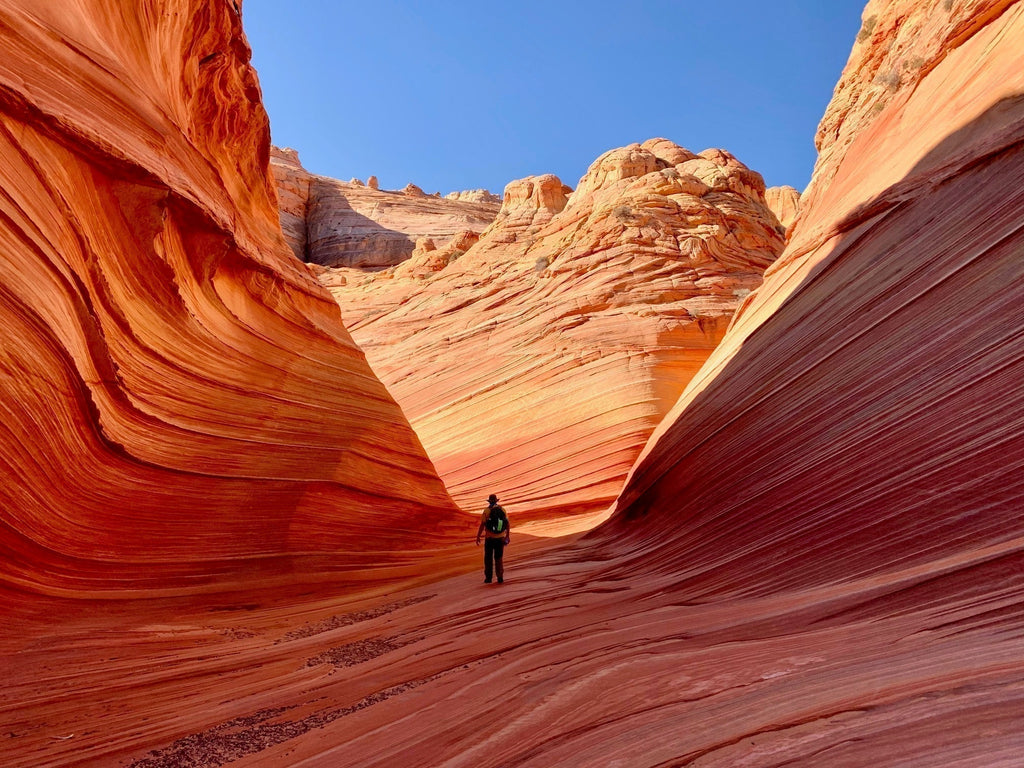
Dan Pierce here. Some hikes are memorable for a variety of reasons; spectacular scenery, the company you shared the hike with, or an especially eventful adventure. My hike into The Wave in Arizona included all three. If you haven't heard of The Wave, you need to look it up. It’s one of those places that is endlessly hyped on the internet for its colorful, carved sandstone landscape. The mystique of the place is heightened because the Bureau of Land Management, who manages the site, currently issues only 64 daily permits through a lottery: 48 through an on-line lottery and 16 through an in-person, day-before lottery (see Logistics Tips at the end for information on obtaining a permit).

Our group of Patty and Joel Anderson and myself were super fortunate to have the first number drawn out of over 90 groups in the in-person lottery in May of 2021. We got up early the next day, made the drive from Kanab down Highway 81 to the rutted and dusty Schoolhouse Rock Road. After 8.3 bone-jarring miles we arrived at the Wire Pass Trailhead. One of the unique things about The Wave is that the trail is not marked. BLM gives you a brochure with pictures of landmarks along the way. It sounds strange, but the route is pretty easy to follow as you’re traveling through totally open country.


The scenery along the way is pretty spectacular, but once you pass through a short slot canyon and actually enter The Wave you’ve entered a magical world. As we had started early, we had the place to ourselves. It’s difficult to describe the play of light against the reds, oranges, browns, and yellow-striped rock. The early morning light and the crisp air of a spring morning seemed to sharpen and intensify the colors. After viewing innumerable pictures of The Wave I was prepared for a special experience, but actually being there was surreal and an experience I will never forget. The morning quiet heightened the experience even more.


Sharing this experience with Joel and Patty made it even better and we spent several hours oohing and aahing as we scrambled over the rocks. We were soon joined by other groups, but probably only saw at most a dozen or so other people.


We headed back toward the trailhead in the late morning as the day started to heat up. This is where the “eventful” part of the trip began. The first part of the trail is shared with a trail that goes to the very popular slot canyons: Wire Pass and Buckskin Gulch. Since Patty had never seen a large slot canyon, I thought we’d take a side trip on the way out. However, instead of taking the path I knew, I decided we’d take a trail we’d passed on the way in that headed in the direction of Wire Pass. Mistake #1! The trail did indeed lead to Wire Pass, but instead of coming out at the entrance to the canyon, it came out on top, looking straight down... 400+ feet down! I looked for an easy way down to the floor of the canyon, but couldn’t find one.

Mistake #2 was in not turning around and going back the way we came to familiar territory. Instead, I decided to lead my dear friends, Patty with a fear of heights, along the narrow edge of the canyon until we came to a cliff that descended to a wide opening between narrow sections of the canyon. To say the climb down was an adventure is an understatement. We edged along narrow ledges, slid down the rocks from ledge to ledge, and hugged the rocks tightly as if our lives depended on it, which they did. Joel was skeptical from the start and kept asking me, “Dan, what are your next two moves?” I bluffed my way along pretending I knew exactly what I was doing, but by the time we had descended only a short way we were committed to either scrambling to the bottom, stopping where we were and hoping for a rescue, or falling to the bottom. Patty later told me she kept thinking near the top, “If we fall here, we’ll die.” As we made it about halfway down, she thought, “If we fall here, we’ll be seriously injured.” Even as we neared the bottom, she thought, “If we fall here, we’ll break several bones.”

After more than an hour, and after some serious praying and promises to myself that I would never do something so stupid ever again, we made it to the bottom. Patty burst into tears of relief and my first thought was that she would never forgive me and that the remaining ten days or so of the trip would be ruined. I did have hope that Patty and Joel would find it in their Christian hearts to forgive me and I do recall thinking that no one I knew enjoyed telling a great story better than Patty. Fortunately, grace was given, Patty had an incredible story that she has reveled in telling on many occasions since, and our trip was salvaged.


If you are ever going to be in the Kanab, Utah and Page, Arizona area, you need to take a shot at The Wave lottery. You will have an unforgettable experience (hopefully not as unforgettable as ours).
And please learn from my mistakes.
Logistics and Dining Tips for The Wave
For information on entering The Wave lottery, check out this website.
There are similar alternatives to The Wave that are easier to access. South Coyote Buttes offers a similar landscape and the permits to access this area are much easier to obtain. Use the same website as The Wave for information. The White Pocket area is also similar and does not require a permit. You do need an off-road vehicle to access both South Coyote Buttes and White Pocket.
Dining Tips: If you’re headed to Kanab after this hike, I’ve got two great recommendations. Big Al’s at the Junction is a classic drive-in (they even have curb service) and a great place for a bison burger and milkshake after your hike. And as an added treat, their décor features ADG vintage poster art! We also love Escobar’s Mexican Restaurant in Kanab. It’s a family-owned restaurant and has great food.

Appalachian Trail - Carvers Gap to Grassy Ridge Bald
4.3 miles out and back. 1200 feet elevation gain.

I have to admit, I’m not a big fan of the Appalachian Trail (AT). Don’t get me wrong, it’s a great idea and it launched a movement for a whole series of long-distance trails our great nation is now known for. But much of the AT is rocky, eroded, monotonous, and the up and downs of the trail wear on you. Plus, the mice in the trail shelters creep me out. But, there are some sections of the Trail that any avid hiker needs to do.

My absolute favorite—and that of many thousands—is the section of the Trail between Carvers Gap and Grassy Ridge Bald. The Trail runs right along the Tennessee/North Carolina border. Indeed, the old foundations of the Cloudland Hotel are near the trailhead. A line was painted down the middle of the dining hall back in the 1910s indicating the state line and also indicating where you could buy and drink alcohol. North Carolina had statewide prohibition beginning in 1909.

The first section of the trail climbs through a red spruce/Frazier fir forest and opens up as you approach the first peak you'll pass, Round Bald. The rest of the hike is completely open as you cross the longest stretch of grassy balds on the AT, crossing rocky Jane Bald and culminating at Grassy Bald. Along the way you have spectacular 360-degree panoramic views.

There is a lot of debate about the origins of these bald areas in the southern Appalachians, but most scholars agree that while there might have been clearings due to natural forces such as frost heave or lightning-caused fires, the balds were expanded and maintained through human action. The high mountains of the region, once cleared, provided ideal summer pasturage for the Scots Irish and other European settlers who had long cultural traditions of upland grazing. The settlers girdled trees and used fire to clear the balds. The constant grazing of cattle maintained their grassy, open character. Currently, the USDA Forest Service uses a combination of mowing, cutting, and removal of invasive species to keep the balds clear of trees and vegetation that competes with the grasses.


The views from the trail are great any time of year, but this hike is a very special treat at two times of the year in particular. In June, the purple Catawba rhododendron are in bloom all along the way and frame the views in a spectacular way. In October, the fall colors blanket the surrounding mountains and create an unforgettable display. The grassy balds also feature plenty of wildflowers in the spring and summer. In addition, due to its openness, the trail offers incredible sunset and sunrise views.

Logistics Tips for Carvers Gap to Grassy Ridge Bald
Carvers Gap can get very crowded, especially on weekends any time of year. June and October can be overflowing with hikers! Go on a weekday if you can, or if you do go on a weekend, get there very early in the morning.
Skyline Trail – Mount Rainier National Park
5.5 mile loop. 1450 feet in elevation gain.

This is another trail that I’ve done that combined spectacular scenery with wonderful companions. I did the Skyline Trail in Mount Rainier National Park with my wife and four adult children as part of a family trip the summer before two of our kids got married. Sharing this hike with my family made it all the more special for me personally, but even without those factors, this hike is one that would be on most folks' “best of” list.

The hike begins at the appropriately named Paradise Area on the south side of Mount Rainier. The trail begins just above the Jackson Visitors Center. Make sure and pay attention to the trail signs as there are several trails that intersect along the way. This hike is basically an up-and-down loop hike and begins with a fairly steep climb up to Panorama Point. Along the way you skirt Nisqually Glacier, encounter dozens of hoary marmots, and pass the intersection of the Pebble Creek and Camp Muir Trail. This is where those intrepid souls who plan to climb to the 14,410 foot summit part ways and head for the Camp Muir base camp. Panorama Point has unforgettable views to the south and on clear days you can see Mt. St. Helens, Mt. Adams, and Mt. Hood. There’s also a pit toilet at Panorama.

From Panorama Point hikers can take the Low Skyline Trail, usually through a snowfield or take the high road on the High Skyline Trail which heads uphill for a bit and skirts the snowfield. I’d recommend, as I usually do, the high road. The hike down passes through a number of meadows which feature spectacular displays of wildflowers and innumerable small ice-cold creeks running off from the glaciers above and meandering through the meadows. We have some treasured photos from this area of the family with wildflowers and the ever-present face of Mount Rainier in the background. Indeed, the greatest thing about this hike is the looming, imposing presence of Mount Rainier the entire way. Near the bottom of the trail you pass Sluiskin and Myrtle Falls, an added treat to this incredible hike.

Whether you have memorable companions for this hike or not, this is one you need to put near the top of your bucket list.

Logistics and Dining Tips for the Skyline Trail
Not much to say here. There’s plenty of parking and nice bathroom facilities and interpretive exhibits at the Jackson Visitors Center.


Dining tip: The Paradise Inn, one of the grand old national park lodges, is adjacent to the Visitors Center and is a great place to relax after your hike. They have a nice dining room for a sit-down dinner and a café for lighter fare which you can eat in the spacious lobby or outdoors on the veranda. It’s a great place to reflect on a truly memorable hike.
Pitamakan/Dawson Loop – Glacier National Park
17.4 mile loop. 2968 feet in elevation gain.

I must have at least one trail on this list from Glacier National Park. I would say that Glacier is, by far, the national park with the most spectacular hiking trails. It’s hard to top the Highline Trail, the Hidden Lake Overlook Trail, the Siyeh Pass Trail, the Swiftcurrent Trail, the Avalanche Lake Trail, the Iceberg Lake Trail, the Grinnell Glacier Trail, or the Piegan Pass Trail. And there are trails I have not done that I know are just as beautiful. But I want to highlight a trail that, I think, combines the best of Glacier National Park—gorgeous alpine lakes, spectacular views, wildlife, and lung-busting climbs over scree slopes—the loop hike from Two Medicine Lake up over Pitamakan and Dawson Passes.

This hike is not for the faint of heart. if you do the whole loop it’s over 17 miles with almost 3000 feet in elevation gain. It’s an all-day affair and a long day at that. You need to start early if you tackle this as a day hike. As daunting as it seems, it’s doable if you’re in reasonable shape and you take it slowly. And remember, the second half of this hike is mostly downhill or mostly level ground.
I’d recommend starting this hike at the trailhead near the Two Medicine Campground and doing it counter-clockwise. You’re going to have a steep climb any way you look at it but the trail is a bit more gradual and less rocky going up this way.
The trail starts with a relatively level couple of miles through forests and across some meadows and streams, a nice way to get warmed up. After a couple of miles, the trail begins to ascend through more open country. This area features great displays of wildflowers during the summer months. We also spotted a mother spruce grouse and her chicks in the grasses along the trail. About four miles in you go back into a forest as you approach Old Man Lake. The lake itself is below the trail, about .3 mile, and is a great place for a snack or a cool wade. The mountains soar above and frame this glacial tarn (lake) and you’ll get great pictures of the mountains reflecting off the lake.


From Old Man Lake, the trail rises steeply along switchbacks across a scree slope to the continental divide above. When you reach the divide you get panoramic views toward Cut Bank and Triple Divide and a sea of high mountains to the north and a great view of Old Man Lake below and behind you. The climb continues steeply from the divide up to Pitamakan Pass across scree. My wife Lydia and I were so proud of ourselves as we trudged up the trail approaching Pitamakan and had such a sense of accomplishment. That is until a 10-year-old boy came running by up the hill. We got a further comeuppance when his 8-year-old sister trailed not far behind. Their very fit parents soon followed. That brief experience in humility, however, did not dampen our elation in reaching the top and viewing the mountains to the west across the valley deep below with several glacial lakes dotting the landscape. The picture taken of us from that spot is still one of our favorites.


The hike from Pitamakan to Dawson Pass hugs a ridge and is probably one best avoided by those with a fear of heights. We saw several female Bighorn sheep grazing above us in this section, one of them playing peek-a-boo through a notch in the rock. Dawson Pass offers another set of truly spectacular panoramic views of the mountains and of the remains of the Lupfer Glacier. From Dawson the trail descends steeply along a rocky trail passing No Name Lake. From No Name it’s a little more than two miles down to the shores of Two Medicine Lake. Here you have a choice of hiking out along the shore of the lake, a great area to see a moose, or taking the boat shuttle back to the developed area of Two Medicine.

Logistics and Dining Tips for the Pitamakan/Dawson Loop
Again, it’s best to start early on this trail. You do not want to get caught out on the trail when darkness falls. And always keep in mind, you’re in grizzly country. Make sure you’re packing bear spray and make sure you know how to use it! If you decide to shorten the trip by taking the boat shuttle across Two Medicine Lake, make sure to buy a ticket beforehand.

Dining tips: We started our day of hiking at the Two Medicine Grill. We love this old-style diner and I always like a good, hearty breakfast before a long hike. We also love Serrano’s Mexican Restaurant in East Glacier and we had a very memorable meal after our hike. The Glacier Park Lodge in East Glacier offers a grand dining room, a lounge for more casual dining, and a coffee shop. It’s worth a stop just to walk through the iconic lobby with its massive Douglas Fir pillars.
Until Next Time...
Next month I’ll start a series focusing on great hiking in specific national parks. I’ll start off with Glacier (which, as you can see above, is the best hiking national park in my opinion). Until then, happy hiking and stay safe out there.
← Older Post Newer Post →